Sunshine and scattered showers to follow flood warnings
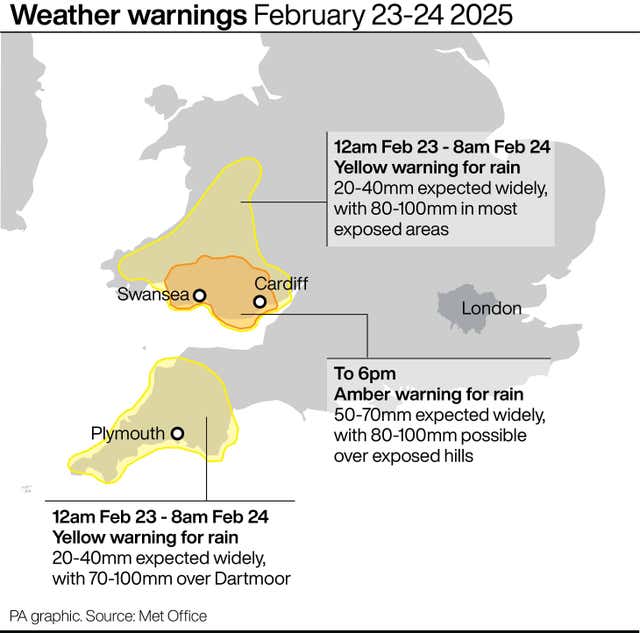
The Met Office issued an amber weather warning for heavy rain and deep floodwater on Sunday.

Sunshine and scattered showers will follow weather warnings issued over the weekend for heavy rain and deep floodwater.
The Met Office issued an amber weather warning for heavy rain and deep floodwater that could cause “danger to life”, as it said flooding and disruption was likely “overnight into Monday”.
The warning covered south and mid-Wales, from Newport to Carmarthen and north to Brecon, between 3pm on Sunday and 6am on Monday.
Yellow weather warnings for rain also came into force for south-west England and much of the rest of south and mid-Wales from midday on Sunday until 8am on Monday.
Natural Resources Wales has seven flood warnings in place as of 6am, along with 30 flood alerts.
Met Office forecaster Craig Snell said rain would gradually make its way eastwards across the UK, adding that Monday would largely be a “day of sunshine and scattered showers”.
Mr Snell told the PA news agency: “By the time we get to lunchtime on Monday, the rain band should have cleared most parts of the UK.
“It’s certainly a much brighter day, a little bit less windy, especially in the south, and that will allow temperatures just to climb a little bit.
“So, for example, in the South East, it could get up to about 13 or 14 degrees.”
The forecaster said that Tuesday would be another day of “generally sunny spells and scattered showers”.
The Met Office said the westerly pattern for the UK is likely to continue through the week, with showers and possibly longer spells of rain and windy conditions likely at times.
The weather service had said on Sunday that fast-flowing or deep floodwater was likely to cause danger to life, as well as warning of possible “delays and some cancellations to train and bus services”.
The Environment Agency warned people not to drive through floods, adding that “just 30cm of flowing water is enough to float your car”, and urging people to sign up for free flood warnings.
Andrew Morgan, leader of Rhondda Cynon Taf council, said Sunday had been a “close call” after thousands of sandbags were distributed to high-risk areas.
Hundreds of homes and businesses in the area were flooded in November by Storm Bert.
Mr Morgan told PA on Sunday night: “It’s been a busy day for the dozens of crews and contractors on stand-by.
“Overall, while there has been isolated issues with culverts, the majority of calls has been for surface water flooding and highways.
“Today has, I believe, been a close call from rivers flooding in some areas. I will be discussing this with Natural Resources Wales in the coming days.”
Sarah Cook, flood duty manager at the Environment Agency, said heavy and persistent rain had brought “a risk of significant inland flooding in parts of south and mid Wales”.
She added that localised flooding was also possible in south-west England and Cumbria on Monday morning.
Ms Cook said: “Impacts could include river flooding and surface water flooding from urban watercourses, drains and channels.
“Please plan journeys carefully and do not drive through flood water – it is often deeper than it looks and just 30cm of flowing water is enough to float your car.”