
Met Office issue strong winds weather warning after rain and floods
Parts of England suffered localised flooding on Friday with a weather warning of high winds on Sunday to come.

A weather warning for strong winds has been issued for Sunday as parts of England suffered heavy rain and localised flooding on Friday.
Commuters in parts of England faced disruption on road and rail services with social media images showing tracks at a train station in Shropshire completely submerged and abandoned cars on an empty motorway in Gloucestershire.
An amber rain warning issued by the Met Office for areas of the Midlands and the south of the country, and a separate yellow rain warning for large parts of England and Wales, both ended on Friday.
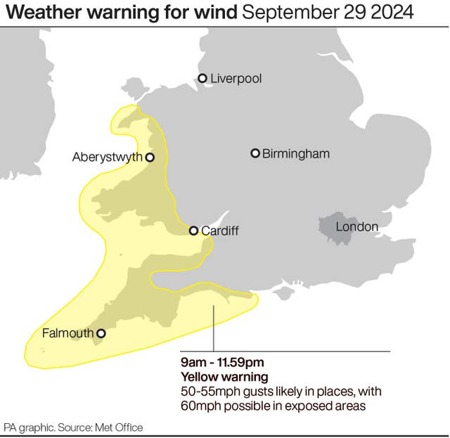
But the Met Office on Friday has now issued a further yellow weather warning of strong winds which may cause disruption across the south west of England and Wales on Sunday.
Winds will strengthen from west to east during Sunday, with gusts of 50-55 mph likely in places, exceeding 60mph in the most exposed areas.
The Met Office said this will be accompanied by outbreaks of rain, heavy at times, which could lead to some surface water and spray.
Winds will gradually ease across Wales and inland parts of south west England through Sunday evening and night, but it may remain fairly windy along some coasts of southern and south-western England during Sunday night.
Some coastal routes, sea fronts and coastal communities will be affected by spray and large waves, with some delays to road, rail, air and ferry transport likely, along with disruption to bus and train services.
Earlier areas affected by the amber rain warning, including Milton Keynes, Oxfordshire, Cambridgeshire, Leicestershire and the West Midlands, were hit by flash floods as the Met Office said the regions could have 30-40mm of rainfall within three hours.
Rail services between Shrewsbury in Shropshire and Wolverhampton in the West Midlands were cancelled, with disruption expected all morning, after severe flooding at Wellington station and a tree on the line earlier.
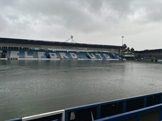
The pitch at the SEAH Stadium in Wellington, home to Telford United football club, was completely flooded on Thursday evening.
Trains between Peterborough in the East Midlands and London King’s Cross were delayed because of flooding.
The Marston Vale line in Bedfordshire, which operates services between Bedford and Bletchley, is suspended until Monday because of standing water on the track.
All lines were blocked between Bicester North and Banbury in Oxfordshire, with disruption expected until 3pm.
National Highways said the M5 in Gloucestershire was closed northbound between junction 16 and junction 14 because of flooding.
The motorway had reopened southbound between J14 and J15, but hour-long delays and up to four miles of congestion were still expected both ways.
Avon Fire and Rescue Service previously said they were working with National Highways South West to rescue people stranded on the M5 in Gloucestershire.
The A421 in Bedfordshire was expected to remain closed in both directions on Friday between the A6 Bedford and M1 junction 13 near Marston Moretaine, as floodwater continued to be pumped clear from the junction.
Meteorologist Greg Dewhurst told the PA news agency: “There will continue to be localised flooding. A lot of these areas have been hit by rain in the past few weeks which means the ground is already saturated.”
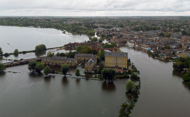
As of around midday Friday, the Environment Agency had issued 63 flood warnings across England, meaning flooding is expected, and 115 flood alerts, meaning flooding is possible.
According to the Met Office warning, the weather could lead to difficult driving conditions and road closures, homes and businesses are likely to be flooded and there is a “good chance” some communities will be cut off because of floods.
Councils and emergency services in Northamptonshire and Hertfordshire said there were a number of road closures and they were working to keep people safe overnight.
Tewkesbury Borough Council, in Gloucestershire, has been handing out sandbags to people to help protect their homes against flooding.
Parts of the country had more than the monthly average rainfall on Monday and there were further downpours on Wednesday.
About 650 properties were flooded in Hertfordshire, Bedfordshire, Northamptonshire, Kent and the home counties, according to the Environment Agency, which estimated around 8,200 properties had been protected.
The agency said heavy rainfall over the last 24 hours across the country has led to localised river and surface water flooding across central England, Yorkshire and the North East.
The current outlook indicates ongoing, minor river flood flooding is expected in Northamptonshire, Cambridgeshire, Worcestershire, Bedfordshire, Gloucestershire, and also in Yorkshire.
Kate Marks, flood duty manager at the Environment Agency, said: “Environment Agency teams continue to be out on the ground, supporting local authorities in responding to surface water flooding.
“We urge people to plan their journeys carefully, follow the advice of local emergency services on the roads and not to drive through flood water – it is often deeper than it looks and just 30cm of flowing water is enough to float your car.
“People should check their flood risk, sign up for free flood warnings and keep up to date with the latest situation as well as following @EnvAgency on X for the latest flood updates.”
Floods minister Emma Hardy added: “I know first-hand how devastating flooding can be and my thoughts go out to those residents and businesses affected across the country.
“I met with those involved in the response on the ground, including representatives from the Environment Agency and its partners, and I want to express my heartfelt thanks for the vital work they have undertaken to help protect their communities.”


