How Birmingham's roads could change in 2025 and beyond
Controversy has often surrounded Birmingham City Council’s plans for its road network.
The authority has ambitions of lowering transport’s damaging impact on the environment; revitalising the city centre and reducing harm, especially with a road safety emergency being declared last summer.
Major proposals have therefore been put forward and could drastically change travel in Brum if they are given the green light – but such plans have frequently proved divisive.
Plans to reduce most of the city’s 40mph roads to 30mph for example split opinion during a public consultation while proposed changes for the A38, which runs through the heart of Birmingham, triggered a fiery debate last year.
Not only that but the prospect of a 20mph speed limit being introduced “city-wide” also led to a fierce debate playing out towards the end of last year.
With all this in mind, here’s a look at the ways Birmingham’s roads could drastically change in 2025 and beyond.
1) Lower speed limits
Divisive plans to reduce most of the city’s 40mph roads to 30mph could soon be going ahead.
Back in 2023, the city council launched a consultation on proposals to review 40mph speed limits as “anti-social and dangerous driver behaviour” continued to be a pressing concern.
Following the declaration of a road safety emergency last summer, cabinet member for transport Councillor Majid Mahmood “fast-tracked” the proposed speed limit reductions.
A new public consultation opened last November on Speed Limit Orders, the legal documents required to make changes to the status of roads.
“Reducing speed limits aims to reduce the risk of road harm by slowing vehicle speeds,” it read. “It also provides consistency across the city, improving driver compliance and aiding enforcement.”
It said changes to the highway, mainly changing and removing signs, would take place early in 2025, subject to approval of this order.
The council also said the costs for the project would come from surplus income from the Clean Air Zone (CAZ) .
This funding is ringfenced for use on transport schemes only and cannot be used for other purposes.
2) ‘City-wide’ 20mph speed limit
There was a fiery debate last year when it emerged that Councillor Mahmood had sent a letter to the government requesting a “20mph zone for the whole of Birmingham”.
“He is currently awaiting a response,” a council report added.
He later told a full council meeting that there is a “desire to have a 20mph speed limit city-wide”.
“This is set out in the Birmingham Transport Plan and we are making lots of progress on this,” he said.
In a statement on the matter, Councillor Mahmood argued that slower speed limits on ‘appropriate’ roads would reduce collisions and save lives.
“For this reason, our Birmingham Transport Plan sets out that 20mph should be the speed limit in residential areas and where footfall is high,” he said.
“Other types of roads will remain unaffected”.
He went on to say that around one third of the city’s roads are already subject to a 20mph speed limit.
“We would like to expand the number of roads subject to this speed limit where appropriate and are currently exploring opportunities to carry this out,” he added.
It’s worth bearing in mind however that it’s still relatively early days and plans to introduce such changes would have to go through consultation first.
3) A38 proposals
Major proposed changes to where motorists can join and leave the A38 in Birmingham city centre could soon be introduced.
The city council has said it wants to bring in a series of measures across the city centre over the next couple of years as it’s transformed into an “attractive place to work and visit”.
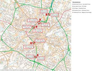
If they go ahead, the plans would leave the A38’s Dartmouth Circus-Lancaster Circus junctions, to the north of the city centre, and the Holloway Circus-Belgrave Interchange, to the south, as the only two ‘weaving section’ locations where drivers heading to the city centre could both enter and leave the route.
Three key junctions between those points would be restricted depending on whether motorists wanted to join or leave the A38.
A public consultation stated: “This will reduce congestion in these locations and is an important first step on the journey to downgrading the A38 and reducing the severance it brings – an aspiration outlined in the Birmingham Transport Plan.”
The council has said its aim is to cut the number of private cars using local roads in the city centre, instead aiming to increase use of the city’s ring road.
It acknowledged a route to a particular destination may change but added that “all locations will remain accessible”.
4) Traffic management areas
The city council has said it wants to remove one bus gate and add another as it looks to transform travel in the heart of Brum.
As mentioned before, the authority has plans to introduce a series of measures across the city centre over the next couple of years – these could include bus gates, bollards and turning restrictions.
The city council said the interventions would lead to greater use of the ring road for private vehicle trips and a reduction of trips on local roads within the city centre – a move it said would improve air quality.
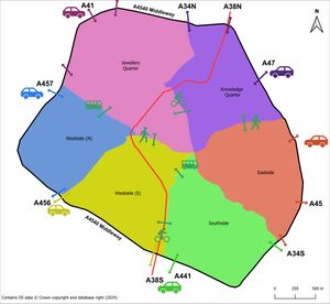
It added they would also complete the council’s planned ‘movement and access arrangement’, a strategy which splits the city centre into six traffic management areas.
A public consultation linked to these plans was launched last year on a number of possible changes, including having no right turn from Broad Street onto Sheepcote Street.
If the proposals are given the green light, there would also be a south-eastbound bus gate on Sheepcote Street, between Brunswick Square and Broad Street, while the existing bus gate at the northern end of Sheepcote Street would be removed.
“This will complete the boundary between the Westside North and Westside South traffic management areas,” the consultation page said.
“Broad Street is a key public transport corridor and simplifying the access arrangements in this location will help with more efficient movement of vehicles of all types.”
The strategy would mean private vehicles would be able to enter each traffic area from the ring road only.
“Private vehicles will not be able to travel directly between the different areas,” it added.
“But public transport and active travel modes will be able to.
“This means the route to a particular destination might change slightly but all locations will remain accessible.”

