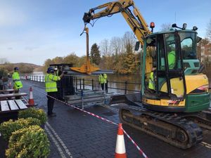
Flood barriers put up in Bewdley ahead of heavy rain predicted across West Midlands
Flood defences have been put up in Bewdley in anticipation of heavy rain across the West Midlands.

The Environment Agency put up the barriers at Severnside North earlier this afternoon, before moving to Hereford to put in place defences there.
Officials made the move as heavy rain is predicted to fall across the region tonight and tomorrow.
Environment Agency manager for the region Dave Throup said crews were "ready to respond" as the West Midlands braces itself for an onslaught of heavy rain over the next 48 hours.
He said in a video message on Twitter this afternoon: "We're putting our low levels flood defences up at the moment at Severnside North in the town and that protects the northern bit of Bewdley from flooding. The river is pretty high – nothing exceptional – and we're putting the barriers up in expectation of overnight rain that's forecast and the very unsettled outlook right the way through.
"The Severn is certainly reacting very quickly. We're also putting some flood defences up at Shrewsbury as well, some low level defences at Frankwell, so we are fully operational."
He added: "We will make a decision on other defences later on once we know whats happening with the rain that's forecast overnight and that remains the deciding factor. There's still a fair bit of uncertainty on where that rain is going to fall although its firming up as probably affecting more southern areas of our patch, so south Worcestershire, south Herefordshire and Gloucestershire in particular could see some very heavy rain over the next 24 hours.
"That's going to push levels up fairly quickly on both the smaller water courses and the main ones. So we'll be keeping a very close eye on that over the next 24 to 48 hours.
"The big question is where the rain is actually stalls and pivots –the current thinking is it's going to be somewhere around the South/West Midlands area. so right in our patch."
Mr Throup said: "So we're ready to respond. We're open 24 hours at the moment. We've got staff in our incident rooms, they're checking the current levels and will be issuing further flood alerts and flood warnings as we go through this afternoon and through the course of tomorrow as that rainfall lands.
"And we have got operational staff out, putting barriers up. Some of them are checking our flood defences, making sure they are ready for whatever the weather chucks at us over the next 24 hours or so. The message remains, please stay flood aware. Check your own flood risk on our website, you can monitor the river levels on there, and you can see the warnings and alerts as you issue them.
"All to keep abreast of the weather forecast as it has changed quite a bit, the focus of the heaviest rain is changing on an hourly basis so where that falls we're likely to see some significant surface water flooding as well."


