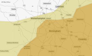
Two weather warnings - one amber - with more heavy rain set to hit Black Country
The Met Office has issued a 12-hour amber warning for heavy rain affecting parts of the Black Country and other areas of the West Midlands.
Watch more of our videos on ShotsTV.com
and on Freeview 262 or Freely 565
The warning says heavy rain is likely to cause flooding and transport disruption this evening and overnight from 6pm on Thursday until 6am on Friday, which is followed by a three-hour yellow warning for rain until 9am which covers a wider area.
In the amber warning, forecasters say: "Slow moving showers and thunderstorms will develop through the afternoon, merging into a large band of heavy rain through the evening, before clearing slowly south overnight.
"Some places, especially across central and eastern parts of the warning area, are likely to receive 30-40mm in three hours or less, and perhaps 50-60mm or more in around six hours.
"This rain will fall onto already saturated ground and affect communities recovering from recent flooding. Travel disruption and further flooding is likely, with rivers continuing to rise after the rain clears."
The warning, which covers also covers Birmingham, Worcestershire and the east Midlands, warns of spray and flooding probably leading to difficult driving conditions and some road closures, with homes and businesses likely to be flooded and damage to some buildings.
Advice from the Met Office continues: "Keep yourself and others safe; prepare to avoid travelling by road during potentially dangerous road conditions. If you must travel, ensure you watch for possible danger and drive cautiously."
They also warned drivers and homeowners to prepare a flood kit containing items such as insurance and any other important documents; a torch & spare batteries; a first aid kit, prescription medicines and supplies for looking after your family members or pets; and warm, waterproof clothes, blankets, food and water.
After that ends, a yellow warning which also covers parts of Staffordshire, Shropshire and Herefordshire, runs until 9am on Friday.
Forecasters said: "Whilst some areas will miss the worst, heavy showers and some thunderstorms will occur during today, potentially becoming more organised across a swathe of Wales and into central and eastern England during Thursday evening and on into early Friday morning.
"10-15 mm of rain could occur within an hour from the heavy showers during today with a few places possibly seeing 30 mm over a few hours. There still remains some uncertainty in the details for Thursday evening and overnight, but some locations may see up 20-30 mm of rain in 2-3 hours and perhaps 40-60 mm in 3-6 hours.
"Given the recent very wet weather, this will bring the potential for further flooding and transport disruption."
One flood alert remains in place just south of Stafford along the River Sow and River Penk.
The Environment Agency has said river levels remain high buy steady, with flooding of road and farmlands possible into Friday.
The agency adds: "Flooding is affecting low-lying land and roads adjacent to the River Sow between Great Bridgeford and Shugborough, the River Penk between Coven and Stafford, the Sandyford Brook, the Rising Brook, the Ridings Brook and the Saredon Brook."
On Monday a number of roads in the region including in Sandwell and Wolverhampton were affected, with one in closed due to flooding after heavy rain at the weekend and into the early part of this week.
For full details on all weather conditions, go to https://www.metoffice.gov.uk/