12-hour thunderstorm warning issued as temperatures continue to climb
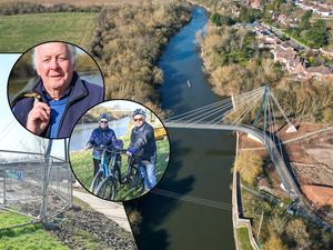
Residents across the Black Country and Staffordshire have been soaking up the sun as temperatures climb before a thunderstorm warning hits later in the week.
Watch more of our videos on ShotsTV.com
and on Freeview 262 or Freely 565
The Met Office has issued an update to residents across the region as a heatwave persists, forcing sun-kissed locals to don shorts, hats and shades to stay cool throughout the week.
According to its most recent update, published today, July 29, residents can bask in the warmth for the next three days as temperatures are expected to hit heights of 27C (80.6F) all the way until Wednesday afternoon, July 31.
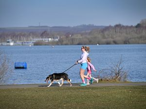
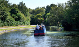
And today, locals across the region are making the most of the surprise weather, walking dogs in Dudley, navigating narrowboats in Stourbridge and getting their steps in playing sports as the sunshine beams from above.
But it won't be this hot for long, as a pesky thunderstorm warning will keep beer-garden punters on high-alert as the week continues to bake.
The Met Office posted the update on its site today and its Chief Meteorologist, Frank Saunders, said: “Much of the UK is entering a warm or even hot interlude of weather, with some places in England and Wales likely to meet heatwave criteria in the coming days.
“Temperatures are likely to peak at around 32C (89.6F) in southeast England on Tuesday and Wednesday, with much of the UK experiencing dry, fine and warm conditions in the first half of the week.”
According to the firm - although today will peak at 27C (80.6F) - West Mids locals can expect a cooler evening tonight with a minimum temperature of 14C (57.2F), while Tuesday and Wednesday will bring the heat yet again - with Wednesday being mooted as set to have 'very warm sunshine’ still.

It said: "Tuesday, another fine, settled day with lots of very warm sunshine. A build-up of high cloud may turn the skies a little hazy at times. Maximum temperature 27C (80.6F)."
It added they'll be 'very warm' sunshine again on Wednesday.
But as Wednesday closes, the site said 'an increasing chance of showers, which could turn thundery' could take its place, which should 'clear eastwards on Thursday with a fresher Friday offering bright spells and showers'.
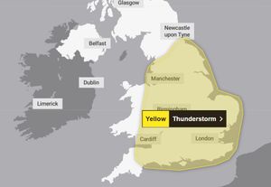
A 12-hour weather warning covering much of the UK - including the Black Country, Staffordshire, Worcestershire and Shropshire - is in place from midday until 11.59pm on Thursday.
The warning has been issued from midday until 11.59pm on Thursday and covers much of the country, including Shropshire, parts of Powys, Herefordshire, Staffordshire and the Black Country.
In their warning, forecasters said: "Heavy showers and thunderstorms are likely to break out across parts of England and Wales on Thursday afternoon.
"The exact location of showers is still uncertain and some places will stay dry all day. However, where the showers do occur they could be torrential, with the additional hazards of lightning, hail and gusty winds."
"The heaviest showers could result in 20-30 mm within an hour, with 24 hour accumulations possibly reaching as much as 70-90 mm where multiple showers affect the same location."
The Met Office says the weather could cause some disruption including flooding that could cause road closures, travel delays and cancellations, and power cuts.
Met Office spokesperson Nicola Maxey warned: "As we move into the middle of the week we start to see an increasing risk of thunderstorms developing, particularly in parts of England and Wales, and the rain is such that it could cause some local disruption.
"This is the sort of rainfall that could cause surface water flooding and heavy rain that takes a while to clear away.
"There could also be some lightning potential for hail and gusty conditions."
The warning covered most of England, stretching from the south coast up through the Midlands and reaching as far north as Newcastle.

A yellow heat health alert was stamped down today across all of England, which will be in place until at least Friday, August 2.
Although most are happy to see the sun come out, it does bring with it warnings to stay safe during unusually hot periods of the year.
Published on the Government website, tips on how to keep cool are: Keeping out of the sun between 11am and 3pm, planning all active hobbies in the cooler parts of the day, closing windows and curtains in rooms that face the sun, drinking plenty of fluids and limiting alcohol intake, wearing suitable clothes, applying sunscreen, and seeking shade.
Locals looking to make the most of the sunshine should brace for last-orders to be sounded around Wednesday afternoon, but will see small windows of warm weather in the following days - so those working throughout the week should get a chance to soak it up before the heatwave ends.