Snow warning for the West Midlands as Arctic blast arrives
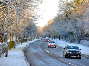
A severe weather warning has been issued with snow expected to land in the West Midlands this week.

The first white powder could fall on Monday, with temperatures set to plunge well below zero from Sunday night when freezing air from Russia blasts the UK.
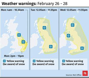
And now the Met Office issued a yellow warning for snow covering all of the Black Country and Staffordshire on Tuesday and Wednesday.
The 'be aware' warning says: "There is the potential for travel delays on roads, stranding of some vehicles and passengers, as well as delays or cancellations to rail and air travel.
"Some rural communities could become cut off. Power cuts may also occur and other services, such as mobile phones, may be affected."
The chief forecaster's assessment was updated on Sunday to say: "Showers will bring a large variation in amounts of snow across even small areas with some places seeing very little snow.
"There is the potential for 10-15 cm of snow in places where showers become more frequent whilst nearby locations may see much less frequent showers and only small accumulations of 1-3 cm in places.

"Strong winds will lead to drifting of snow, and lightning could be an additional hazard, particularly near North Sea, Irish Sea and English Channel coasts.
"By the end of Wednesday, more than 20 cm may have accumulated in places in some eastern counties of England, Scotland and Northern Ireland from a culmination of Monday, Tuesday and Wednesday's snow showers."
A severe weather warning covering the east of England has also been issued for Monday, when overcast skies and light wintry showers are likely to replace the clear skies seen in the West Midlands this weekend.
The warning then covers all of the West Midlands and most of the country from the early hours of Tuesday until midnight on Wednesday.
On Friday the Met Office issued an amber cold weather alert - one stage below a national emergency - for all of England until Thursday.
The cold blast - dubbed the 'beast from the east' - is expected to bring temperatures as low as minus 8C (17.6F) on Sunday night, making it the coldest late February in five years.
A forecaster joked that spring had been "postponed" due to the chill arriving from the east just before March 1 - the first day of the meteorological spring.
Met Office meteorologist Martin Bowles said the mercury will drop to as low as minus 5C (23F) in London on Sunday night, while snow is likely in the capital from late on Monday and into Tuesday.
Temperatures of minus 8C are expected widely across the rest of the country.
Mr Bowles said: "Somewhere like the Scottish mountains might go lower than that, but that's actually quite normal in the Scottish mountains, whereas it's definitely not normal to have minus 5C in London at the end of February.
"We haven't had temperatures that low in late February since 2013. It's not unheard of. There are records that are lower than that."
He added: "But it is quite unusual, particularly as it's quite late in the season.
"We refer to March 1 as being the first day of spring and of course March 1 will be right in the middle of this cold spell, so spring will be postponed for a couple of weeks, shall we say."
During the day on Monday, temperatures of 1C (33.8F) and 2C (35.6F) are expected across much of the country, while Northern Ireland will escape the worst of the cold due to its western position.
The snowiest winter of the twentieth century in the United Kingdom was 1947 when snow fell every day somewhere in the country from January 22 until March 17.


